|
But
I had hiked this trail before on my way to Mts
Avalon and Field, so I had a pretty good feel of where the trail was
going. None-the-less, I began to pay more careful attention to where I was
going, searching for any near or distant blazes to ensure that I was going
the right way.
At the junction of the Avalon and A-Z Trails, I stopped to rest and
have a snack. I wondered how hard the trail would be to follow from here
on. At least I'd been on the Avalon Trail before; the A-Z Trail was
unknown territory. I soon found out. A short distance from the trail
junction, the A-Z Trail plunged very steeply down into a ravine and up the
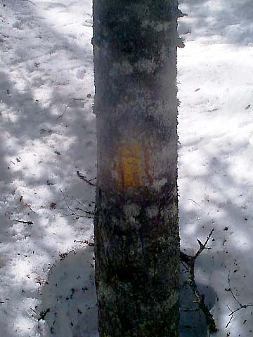
other side. From then on, I had to look very carefully for the yellow
blazes on the trees. I lived for those blazes. Sometimes, I was lucky and
could see the next blaze from a distance. Usually, I just followed my
hunches.
Unfortunately,
this didn't always work. In several places, there were no blazes to
be seen, nor were there any clear indication of which way the trail
went. At these times, I had to set out from the last blaze in what I thought
was the right direction and keep checking the trees for any signs of
a yellow paint splotch and the snow for any signs of previous foot
traffic. If I didn't find another blaze after a while, I'd return to
the previous one and try a different direction. Usually, while this
was happening, I'd also end up postholing, snowshoes and all, or
plunging into a spruce trap. When I finally found the next blaze, I
was elated. Then I'd start the process all over again.
Finally,
I came to a point next to a snowy brook bed where I felt it was possible
that the trail might cross over to the other side. Oddly, blazes on both
sides of a tree directly in front of me seemed to indicate otherwise. If
the direction the blaze on the other side of the tree faced indicated the
direction of the trail, it went up a very steep hill away from the brook.
But that didn't look likely. The second most likely direction was straight
ahead, so I took off my pack and followed what seemed like a trail for a
short distance, all the time looking for a way to veer off to the left to
meet the possible path up the steep hill. I tried a few different
routes, then gave up and headed back to my pack. After eating a piece of
cheese and taking a drink of water, I tried going straight ahead again,
but without looking for a way to branch off to the left. Soon, I thought I
had found it, and continued on, waiting for a confirming blaze. But after
climbing at least 200 vertical feet uphill, I gave up and went back down.
Wondering
whether I might have to give up, I
thought again about crossing the brook. But I didn't, because the paint
blaze on the other side of that tree clearly faced in the direction
of the trail. So I tried the steep hill. I never made it up because it
was way too steep for my snowshoes to handle. I fell, barely managing to
escape a sliding into a tree trunk and getting hurt. Dejected, I decided
to take a photo of the blaze mark because I thought it would be as far as
I end up going. At least I'd have the last yellow blaze photo to show for
my efforts. |
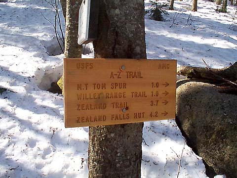
Junction
of the A-Z Trail and Avalon Trail. After this point, the trail became all
the more difficult to follow and I had to use all the trail-finding skills
I could muster to continue on in the right direction. |

|